
Those who grew up in Central Idaho probably studied the Lewis and Clark tale in elementary school. I think it was fourth grade when the story was told to me and my peers, in Mrs. Hoffman’s class, as we studied Idaho history.
Over the years, I’ve had a keen interest in this part of Idaho’s history, especially as it relates to the overall history of the United States. The early exploration of Idaho and subsequent settlements played a pivotal role in westward expansion in the United States, especially as it affected the people who already lived in the land – the Native American Indians.
We know that Idaho did not become a state until 1890 and before that, it was considered the Idaho Territory, so to keep the context of the times, we must remember that in 1804, when Lewis’ and Clark’s Corps of Discovery set out, there was no state of Idaho; it was just expansive, largely unexplored territory.
I remember well the day in 1972, I took a short car ride over Lemhi Pass into Montana. I will always remember the beauty of the scenery as I traveled through those mountains and observed essentially what Lewis and Clark saw as they came through, going the opposite direction. Lemhi Pass is where Lewis and Clark entered present day Idaho.
The Lewis and Clark story began in 1804. The United States, under the presidency of Thomas Jefferson, was a young nation, eager to expand and explore its newly acquired territory from the Louisiana Purchase. Jefferson appointed Meriwether Lewis to lead an expedition, who in turn chose William Clark as his co-commander. Their mission? To explore the uncharted American West, establish trade with Native American tribes, and find a water route to the Pacific Ocean.
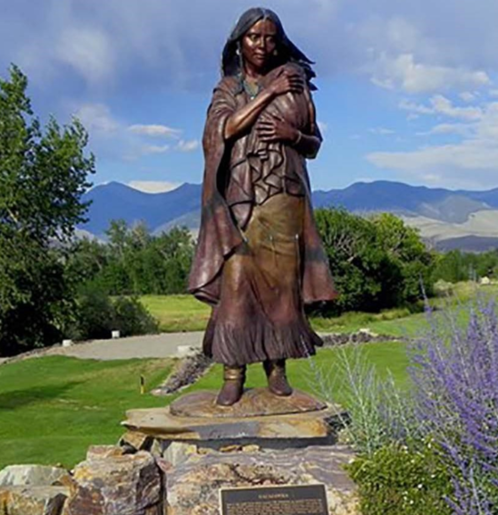
In one of the most pivotal decisions of the Lewis and Clark expedition, the inclusion of Sacajawea, a young Shoshone woman, marked a turning point in the journey’s success. This decision, rooted in necessity and foresight, profoundly influenced the course of the expedition and the historical narrative of the American West.
In November 1804, the Corps encountered Toussaint Charbonneau, a French-Canadian fur trader, at the Hidatsa-Mandan Settlement near present-day Bismarck, North Dakota. Charbonneau, who had two Shoshone wives, one of whom was Sacajawea, offered his services as an interpreter. Recognizing the potential value of his wives’ knowledge of the land and native languages, Lewis and Clark agreed to hire Charbonneau, with the understanding that Sacajawea would accompany them.
Sacajawea’s inclusion in the Corps of Discovery was strategic. Lewis and Clark anticipated that her knowledge of the Shoshone language and terrain would be invaluable, especially in acquiring horses from the Shoshone tribe necessary for crossing the Rocky Mountains. Furthermore, her presence signaled peaceful intent to other Native American tribes, as a war party would not typically include a woman.
The decision to bring Sacajawea along proved to be fortuitous. Beyond her language skills and geographical knowledge, Sacajawea’s presence had a calming effect during encounters with Native tribes. In one notable instance, her reunion with the Shoshone Chief Cameahwait, who turned out to be her brother, facilitated the procurement of horses vital for the expedition’s success.
Sacajawea’s contributions extended beyond diplomacy and interpretation. She gathered edible plants and offered crucial survival skills that she had learned from her upbringing with the Shoshone and her time with the Hidatsa. Her insights into the natural history of the regions the Corps traversed were also invaluable to the expedition’s scientific pursuits.
Fast forward to the summer of 1805. Lewis and Clark, along with their Corps of Discovery, had already faced immense challenges – harsh weather, difficult terrain, and the daunting task of mapping uncharted territory. As they entered present-day Idaho via Lemhi Pass, they were about to encounter some of their greatest obstacles yet.
Idaho’s landscape was unlike anything the Corps had seen. Vast, rugged mountains, dense forests, and rough running rivers. The expedition’s skill in navigation, both by land and water, was put to the ultimate test.
The Corps traversed through Montana’s Horse Creek Prairie to Lemhi Pass, arriving on the Continental Divide and the Montana/Idaho border on August 12, 1805. One of the farthest headwaters of the Missouri had been reached.
Their path then proceeded down the west side of the Divide to Idaho’s Lemhi River Valley, trailed north to the Salmon River, then back into Montana again somewhere in the area of what would become Lost Trail Pass.
One of the most profound experiences the Corps encountered on their expedition was with the Salmon River, often referred to as the “River of No Return”.
The group was seeking a water route to the Pacific Ocean, and they hoped the Salmon River would provide a navigable leg of that route. However, what they were confronted with was a river with rapid currents, steep, rugged banks, and large, hazardous rocks – a route not safe and practical for dugout canoes.
The treacherous rapids were unlike anything they had navigated before. Lewis described the river as “foaming and roaring through rocks in every direction so as to render the passage of anything impossible.”
I remember as a kid, a couple of men from out of state decided to take a canoe through Dump Creek rapids on the Salmon River. The canoe was promptly swamped, and the men were dumped into the swift current. One man lived to tell the tale after he swam out of the river somewhere below the rapids. His buddy was never seen again.
I grew up swimming and rafting in the Salmon River. I was taught early on how to recognize ‘sleeper rocks,’ eddies, and other deceptive dangers that could kill a person. Even some of the most experienced river enthusiasts occasionally encountered bad luck. Everyone learned to respect the River of No Return.
The Corps’ encounter with the Salmon River forced a crucial decision. Recognizing the impossibility of navigating the river, the group had to consider alternative routes. This led them to explore overland paths, even though this meant confronting the daunting Bitterroot Mountains. The decision to temporarily abandon river travel was a significant deviation from their planned route and a testament to their adaptability to the terrain.
The journey through Idaho was marked by both hardship and triumph. One of the most significant challenges was crossing the Bitterroot Mountains. This treacherous stretch was an ordeal of steep climbs, limited food, and harsh weather. But the Corps was driven by determination to press on despite winter setting in.
As I recall growing up in the Salmon River Valley, we would get the first frost of the year sometime in August. And it was common to see snow in the mountains not long after that first frost. According to their journal records, the group encountered snow and rough conditions as they headed through the narrow valley past present day Gibbonsville and over Lost Trail Pass. The group was being led by an Indian guide named Toby.
The lingering question is whether or not the group was “lost” or just disoriented as they approached the high mountain pass. Clark’s journal for September 3, 1805, informs us that at the end of that day as the group attempted to cross the divide near the present-day Lost Trail Ski Resort, they “encamped on a Bran[c]h of the Creek [they] assended after crossing several steep points and one mountain.” We can’t say for sure that they were lost, and they didn’t admit to it in so many words, but one journal entry gives us a hint: “This was not the creek our guide wished to have come upon.”
In July 1997, the Salmon and Challis National Forests and several other agencies and associations, sponsored a symposium of five amateur and professional historians and cartographers, each of whom described and illustrated his own theory as to the route the Corps might have followed, and the location of their camp on that night. The event was highlighted by an on-site exploration of each of the possibilities. In this instance, hindsight served merely to illuminate the scope of their uncertainty, but it dramatically underscored the adventure that the men faced almost daily on their journey through the wilderness.
Clark’s journal continued: “but little to eate I killed 5 Pheasents [grouse] & The huntes 4 with a little Corn afforded us a kind of Supper.” Another was physical danger. They struggled over “emence hils and Some of the worst roade that ever horses passed.” Frequently the horses fell, and in one such instance, lamented Clark, “we met with a great misfortune, in having our last Thmometer broken by accident.” Worst of all was the weather. At dusk that day it began to snow, and misery continued to pile upon misery—”Snow about 2 inches deep when it began to rain which termonated in a Sleet.”
Those journal entries written by some members of the Corps offer us a window into the world of difficulties and hardships encountered by the group as they traversed present-day Lemhi County. For those familiar with the Lost Trail area, imagine riding over that pass on a horse or hiking, in September, after a fresh snow fall. I’ve done it with good boots and warm clothes, which was not easy, mainly due to the thick timber and steep terrain.
Today, the Lewis and Clark National Historic Trail runs through Idaho, allowing modern adventurers and sightseers to experience a part of this incredible journey. The trail serves as a reminder of the expedition’s contributions to the expansion and understanding of this part of United States history.
Visitors along the Lewis and Clark trail in Idaho should make a point to visit the Sacajawea Interpretive, Cultural, and Educational Center, which is dedicated to honoring and providing education about America’s great historical heroine, Sacajawea, and her role in the Corps of Discovery. The center is located in Salmon, Idaho, the birthplace of Sacajawea.


Leave a comment